


 Not everyone will see rain this holiday weekend, but those who do may be in for severe storms.
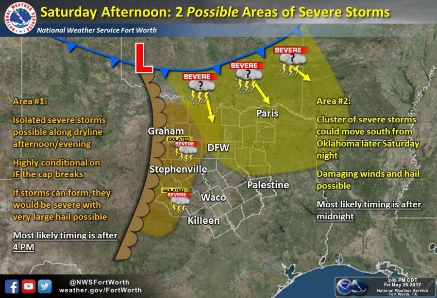
Two areas of thunderstorms are possible in Denton County on Saturday. The first will be in the afternoon and evening along a dryline if the cap weakens sufficiently for storms to develop. If storms are able to form, they would likely be severe with the potential for large hail and damaging winds.
The second area to watch will be a cluster of storms developing in Oklahoma that could move southward into North Texas later Saturday night. These storms could also be severe with damaging winds possible.
A Heat Advisory in effect on Saturday afternoon with heat index values in the 103 to 107 degree range.
Scattered thunderstorms will be possible on Sunday along a slow-moving cold front. A few strong or severe storms will be possible, especially during the afternoon hours. The day is not expected to be a washout as coverage of storms is only expected to be around 30-50%.
Memorial Day should be mostly sunny, with a high near 85.
Check the latest forecast here and follow us on Twitter for frequent weather updates.
A Heat Advisory will be in effect Saturday from 2-7pm. Heat index values above 100 degrees expected in most areas. #dfwwx #txwx #texomawx pic.twitter.com/l8XWQiSWiN
— NWS Fort Worth (@NWSFortWorth) May 26, 2017
Storms NOT guaranteed Saturday! Development very dependent on the cap! Cap holds=no storms. Cap breaks=isolated severe storms. #wfaaweather pic.twitter.com/TbeAggU2SR
— Pete Delkus (@wfaaweather) May 27, 2017


