


 Residents are invited to stop by Argyle Town Hall to see the display of a proposed land use map as well as chat with town officials about the differences from the current land use map.
From 6 p.m. to 8 p.m. tonight and 10 a.m. to noon on Saturday, town officials will be at the town hall to explain the differences between the current comprehensive land use plan approved in 2009 and the one that could be proposed to both the Planning and Zoning Commission and the Town Council in coming months.
The purpose of the question and answer sessions, says Town Manager Paul Frederiksen, is twofold – to let residents come and see the plan in detail and to gather input from residents to help council in considering what the new comprehensive land use map should look like.
“We are interested in getting feedback from Argyle residents,” he said, adding that it is essential to get feedback to help town officials and the council create a land use plan that reflects what the community wants.
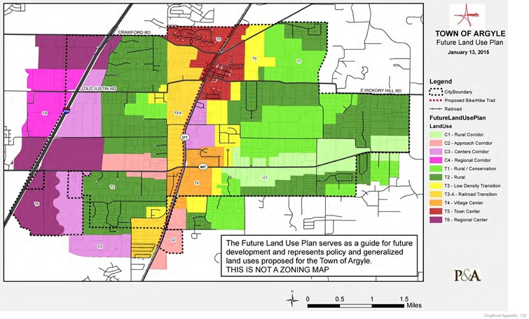
The proposed map delineates the different land use categories using specific property boundaries. It also realigns existing development with designations that closely reflect what is already in existence, according to town documents.
The proposed map adds a new category, T3-A, which covers an estimated 400-500 acres along the railroad.Known as the Low Density Railroad Transition, the category would exclusively require single family residential uses with a recommended density of 1 unit per acre or maximum density of 1.25 units per acre with a minimum of 30 percent open space to allow for the development of public trails as well as landscaping and buffer zones. The current comprehensive land use plan allows a higher density rate with neighborhood commercial use on 10 percent of the property and public facilities on another 15 percent of the property.
For example, under the current plan, a total of 608 duplexes or 396 single family homes would be allowed on the property. Under the proposed plan, 241-299 single family homes would be allowed with no townhomes or multi-family development allowed in the T3-A designation.
The proposed comprehensive land use plan also removed the discouraged category, allowing only recommended or suitable categories.
“This will clear up what you can and cannot do,” said Trent Petty of Petty & Associates, which has worked with the town for several years as well as other communities across nine counties throughout the Dallas-Fort Worth region.


